
Amidst a growing importance in Biodiversity Net Gain (BNG) for new developments, the lack of practical metrics for UK social landlords to manage biodiversity and green spaces for existing land portfolios has become apparent. This gap presents an opportunity to explore the potential of advanced technology in assessing the impact of BNG initiatives on biodiversity.
SHIFT conducted a pilot project to assess the feasibility of using satellite data and implementing BNG calculations for existing homes. The dataset was analysed by overlaying it with property shape files to evaluate the accuracy of satellite readings compared to measured data. Subsequently, this data was integrated with Natural England’s BNG calculator to generate proprietary units termed ‘Habitat Units’.
The results of these calculations and analyses are depicted in the graph below:
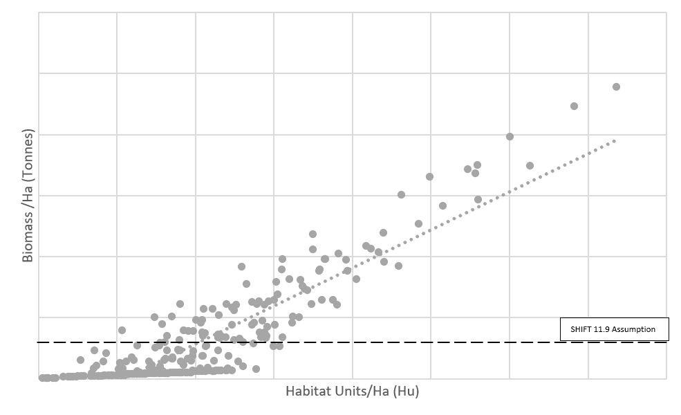
From this pilot project, SHIFT was able to establish a preliminary benchmark using the BNG metric, aligning with our historic assumption of 11.9 tonnes of above ground biomass per hectare.
Using satellite data to assess biodiversity in a social landlord’s land portfolio is a highly novel approach. The benefit of doing so has the potential to provide a way of using verifiable data in a consistent manner. This will enable more consistent and quicker reporting. Quicker reporting means quicker feedback and provides data on whether interventions are needed to create more biodiversity. Crucially, it also highlights whether enough has been achieved and the landlord’s focus can be directed to other environmental issues.
Key conclusions drawn from this study include:
- Earth observation data effectively matched observed ground data.
- Biodiversity Net Gain methodologies can be adapted for existing homes, with satellite data providing crucial raw data such as vegetation types and areas [1]. SHIFT interpreted this data according to guidance to derive values for distinctiveness, strategic importance, and condition to calculate Habitat Units, the metric used in BNG.
- SHIFT derived a BNG estimate for the study area, which could potentially be extrapolated to assess a landlord’s entire land portfolio.
- The estimation of BNG using factors other than satellite data requires refinement. Factors such as dwelling density and build year appear to be significant, yet the correlation between modelled and observed data was found to be weak. Further investigation is warranted to explore additional data and factors that could enhance the accuracy of the model.
- While the study hints at the possibility of defining a benchmark for biodiversity metrics, additional research is necessary. By comparing the derived SHIFT target with Habitat Unit data, an initial target for Hu/Ha could be proposed. However, due to the limited data and sample size, further study is essential to establish a more concrete benchmark.
In summary, this pilot project showcased the potential of leveraging advanced technology such as satellite data in assessing and managing biodiversity within residential areas. The findings highlight the importance of continued research and refinement to establish robust metrics and benchmarks for BNG initiatives.
If you would like to conduct a similar study for your portfolio, please be in touch on [email protected]
[1] – This data provided by specialist earth observation consultancy Gentian https://www.gentian.io/